Introducing the Cooks River Catchment Map for the Cooks River Alliance
I’m pleased to share the completion of a recent commercial engagement by UrbanSpectra in collaboration with the Cooks River Alliance: the Cooks River Catchment Map.
The Cooks River Catchment Map is a user-friendly interactive map, designed to maximise the visibility, accessibility and accountability of improvements in the Cooks River catchment.
This easy-to-use catchment map effectively creates a 24/7 planning and reporting mechanism, increasing visibility for the public and providing information, accountability and tracking for decision makers.
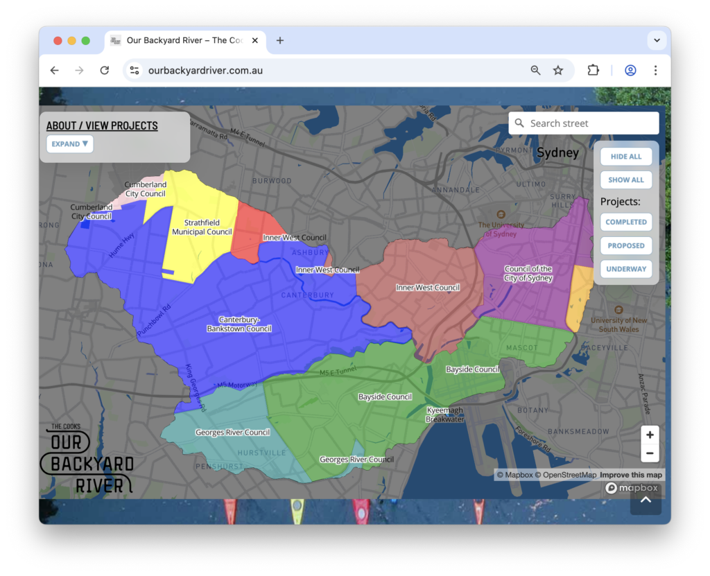
Cooks River Alliance is a partnership between organisations in the Cooks River Catchment, including Bayside Council, Canterbury-Bankstown Council, Inner West Council, Strathfield Council and Sydney Water.
The map is published at ourbackyardriver.com.au, and includes a table displaying the status of projects taking place in the catchment.
UrbanSpectra is a studio building data-driven mapping and urban analysis software for cities with a vision, founded by Jake Coppinger. UrbanSpectra brings a digital-native approach to understanding and improving cities, with great respect for direct observation and community engagement.
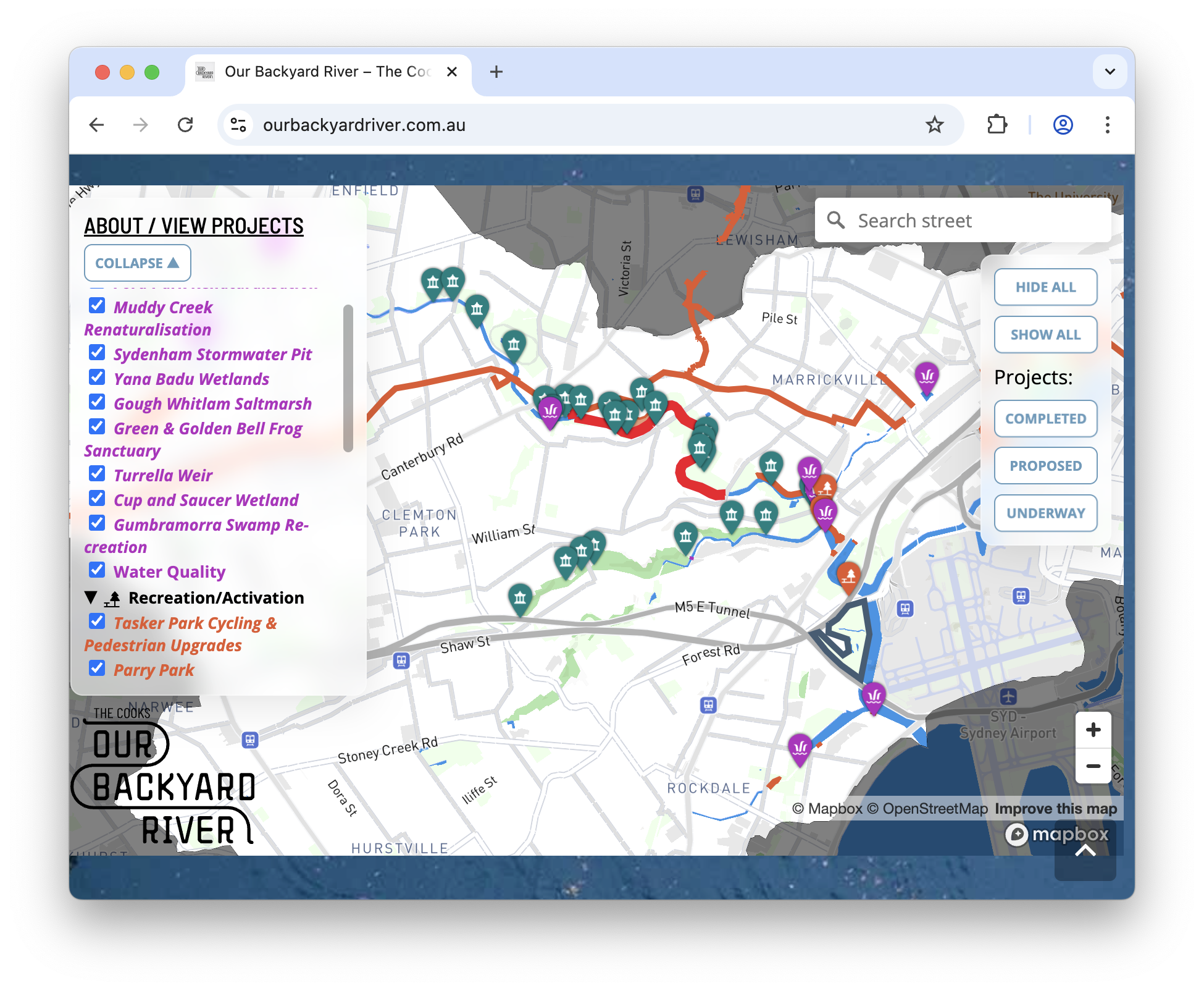
Table of contents
Subscribe for updates from UrbanSpectra
The Map
Drawing on examples like the Los Angeles River Revitalization program, the Cooks River Catchment Map is designed to be a tool for the public and decision makers to understand and advocate for a healthier river.
The map was built by UrbanSpectra, however editorial control of what is displayed on the map (and ongoing updates) remains under the care of the Cooks River Alliance.
The Cooks River Alliance aims to address the complex environmental problems of the Cooks River Catchment. The river runs through some of the most heavily urbanised and industrialised areas in Australia, but much of the catchment takes in popular walking trails and cycle paths, parks and facilities and significant native flora and fauna.
The map enables users to quickly see all proposed, under construction or completed projects across the entire catchment at one click. The features on the map remain an ever-improving work in progress, with continued updates and additions by the Cooks River Alliance as new projects are completed or data becomes available.
If you have feedback on the map, the Cooks River Alliance would love to hear from you – please contact them at [email protected].
Community Efforts
The condition of the river has improved considerably in recent years, in large part due to persistent efforts by local community groups and stakeholders.
The map pinpoints bushcare sites under the care of the well-known Mudcrabs, a local community group caring for the Cooks River, regularly restoring bushland and removing rubbish. The map highlights bushcare sites by the Wolli Creek Preservation Society, a wholly volunteer organisation caring for the bush since the 90s (which also saved the Wolli Creek Valley from the proposed surface M5 expressway along the Wolli Valley past Turrella). The map points to the Cooks River Paddle Trail, which assists canoe and kayak enthusiasts to explore the river – and whose volunteers have removed at least 1.2 tonnes of litter.
Showcasing the information and efforts of work by local community groups is a critical function of the map, which links to these organisations and helps users learn about nearby efforts they could join.
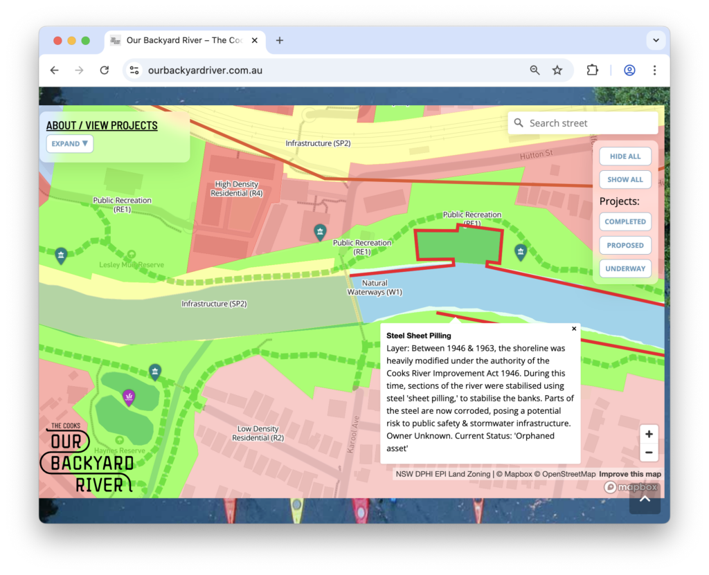
The map also visualises the extent of the sheet steel piling along the river, which has been a significant focus of the community and was extensively discussed at the recent forum hosted by the Cooks River Catchment Community Collective in November 2025.
Council Projects
There are lots of great projects happening in the Cooks River catchment, by a number of distinct councils and organisations. Varied projects include park upgrades, new boat ramps, new footpaths, cycleways and lighting improvements. All the data on the map is also displayed in a tabular format on the about page for easy stakeholder reference.
Engineering
UrbanSpectra undertook product and software development for the map, working closely with the Cooks River Alliance through regular check-ins and a structured evaluation of potential solutions and platforms before build. CRA staff tested the map and admin tools in blitz-review sessions, and the team kept a shared feedback register to prioritise fixes before launch.
A significant challenge in the initial brief was empowering non-technical Cooks River Alliance staff to create and continuously update map layers, including the ability to import data from external sources (such as council documents) which are typically published as non-georeferenced raster images.
UrbanSpectra developed an innovative solution to enable CRA staff to georeference maps in documents using a browser-based tool without any software installation required, integrating with the existing CRA data storage to load data into the map – all without the need for any technical geospatial or GIS expertise.
A map is only useful if it is accurate and up to date. Along with existing data held by the Alliance, the Cooks River Catchment Map enables CRA staff to ingest features directly from OpenStreetMap, as well as georeferencing documents as they become available and from their own and other sources. This enables up-to-date layers from community and government map contributors, such as proposed and under-construction cycling infrastructure. The flexibility of running queries on OpenStreetMap data supports unlimited flexibility for future features and layers.
The project was originally only required to investigate and evaluate options for a draft map solution and a beta version, however thanks to initial prototyping and the flexibility of the solution it has evolved into a functional production-ready map.
UrbanSpectra approached the project in an iterative manner, with early prototypes and spikes to align stakeholders amid a wide-open project brief to identify necessary functionality. UrbanSpectra assisted with branding and defining the scope of the project.
Initial prototypes leveraged familiar interfaces for the team like spreadsheets and Airtable before developing a more flexible custom backend – which takes non-technical users step-by-step through the process of georeferencing maps and adding data to the map. UrbanSpectra also delivered detailed technical and user training documentation.
From a technical perspective, Jake Coppinger led all aspects of the solution design and delivery, including:
- Product co-design and scoping with the Cooks River Alliance team
- Project management and delivery oversight, using an incremental approach with a rapidly improving deliverable and tight feedback loop.
- Full-stack software development, from the frontend design, serverless backend with authentication, hosting and ingestion of data from external sources.
- Graphic design
- Technical and user training documentation
The result is a reliable, easy-to-use (and easy-to-maintain) custom map built on industry-standard technologies, with comprehensive documentation and extensive flexibility for future feature development.
What’s Next?
If you have an interesting challenge in the urban analytics, planning or community consultation space and would like to collaborate – let’s chat: [email protected]
While currently developing software, UrbanSpectra is available for new projects.
UrbanSpectra founder Jake Coppinger writes about policy advocacy and open-source projects on his personal blog at jakecoppinger.com.
This blog post has been reviewed with the client before publication.